Munsiyari – A Splendid Hill Station in Uttarakhand
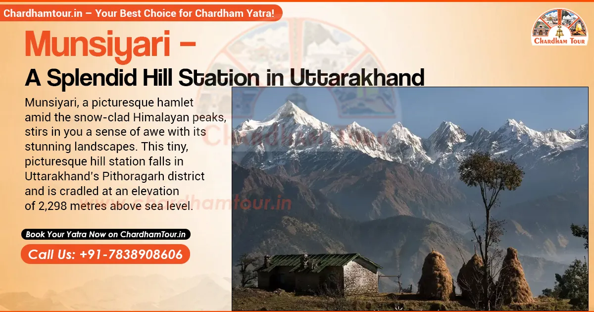
Munsiyari is a small Himalayan town in Uttarakhand's Pithoragarh district, sitting at around 2,300 metres with the five snow-capped Panchachuli peaks filling the skyline. It's the base camp for treks into the Johar Valley — Milam, Ralam and Namik Glacier all start from here — and it stays quieter than Nainital or Mussoorie simply because getting there takes real planning. This guide covers what to see, when to go, how to reach it, what it costs, and the permit rules most guides skip.
Key Takeaways
- Munsiyari sits at around 2,300 m in Pithoragarh district (official sources range 2,135–2,298 m). Kathgodam and Pantnagar are both roughly 250–300 km away by road.
- April–June and September–November generally bring clearer weather. The monsoon (mid-June to mid-September) brings real landslide risk on the Thal–Munsiyari road — avoid it if trekking.
- Town sightseeing needs no special permit. Trekking toward Milam or Ralam, near the Indo-Tibet border, requires ITBP checkpost registration for Indian nationals and an Inner Line Permit for foreign nationals — confirm current rules locally before you go.
- Budget 2–3 nights for the town and Khaliya Top viewpoint; 4–5+ nights for a summit attempt or a glacier trek.
- Milam, Ralam and Namik Glacier routes run 59 km, 45 km and 43–46 km one-way from Munsiyari, per the district administration's own route table.
About Munsiyari
Munsiyari means "place with snow," and the Ministry of Tourism's own description calls it that. It sits at around 2,298 metres (government pages vary between 2,135 and 2,298 m depending on which one you check) on the banks of the Gori Ganga river. It's also known as "Little Kashmir." The town marks the entry to the Johar Valley, once a trade route between Kumaon and Tibet, and it's still the last motorable town before that route continues on foot toward Milam.
It isn't only a viewpoint stop. Trekkers heading toward Milam Glacier, along with mountaineers and researchers working in the Johar Valley, pass through Munsiyari on their way — which is part of why the town still feels like a working base rather than a resort built for day-trippers.
Quick Facts
| Fact | Detail |
|---|---|
| District | Pithoragarh, Uttarakhand |
| Region | Johar Valley, Kumaon |
| Altitude | ~2,298 m (government pages range 2,135–2,298 m) |
| Distance from Pithoragarh town | 135–154 km (sources vary) |
| Nearest railhead | Kathgodam — 270–300 km |
| Nearest airport (regular flights) | Pantnagar — ~250–280 km |
| Nearest airport (by distance) | Naini Saini, Pithoragarh — ~94 km, limited flights |
| Milam Glacier trek | 59 km one-way |
| Ralam Glacier trek | 45 km |
| Namik Glacier trek | 43–46 km |
Places to Visit in Munsiyari
Panchachuli Viewpoint
The five Panchachuli peaks (6,334 m to 6,904 m) dominate the horizon from almost every corner of town. Locals will tell you the same thing: go at sunrise. The peaks shift from pale gold to fiery orange in about fifteen minutes, and by mid-morning the haze usually softens the view.
Khaliya Top
A high-altitude meadow with views of Panchachuli, Nanda Devi, Nanda Kot and Rajrambha. Figures here vary by source: the roadhead at Balati Bend/Balati Farm is cited anywhere from 7 to 9 km before Munsiyari, and the trek from there to the top runs 5–12 km depending on the exact route and whether you count a round trip. Altitude is usually given as 3,500 m, though some sources push it to 3,800 m. Confirm the current trailhead and distance with a local guide or operator before you go — it changes by route.
Betulidhar
A meadow just outside town, known for rhododendron blooms in spring and for being one of the better sunrise-and-sunset spots that doesn't require a long trek. Locals also use its gentle slopes for winter skiing practice.
Kalamuni Pass
Often skipped by first-time visitors but worth the detour — Kalamuni Pass sits en route to Munsiyari, surrounded by oak and birch forest, with a small Kali Temple at the top and a clear, uncluttered view of the Panchachuli range. Worth a stop if you're driving in from Thal or Munsiyari.
Thamari Kund (Thamri Kund)
A quiet alpine lake ringed by paper birch and alpine forest. It's reached via a trek through Betulidhar rather than a direct walk from town, so treat "a few kilometres" as approximate and check the current route locally. Early morning is your best shot at spotting musk deer here.
Nanda Devi Temple
A 3 km trek from town leads to this revered shrine, where the presiding deity is worshipped in the form of Goddess Nanda Devi. It's a modest, quiet temple rather than a grand structure — the walk there, through forest and terraced fields, is as much the experience as the temple itself.
Maheshwari Kund
A small lake about 2 km from Munsiyari, tied to a local legend about a Yaksha and a village curse. Beyond the folklore, it's a peaceful, uncrowded spot with clear Panchachuli views.
Tribal Heritage Museum (Masterji Museum)
Set up by Dr. S.S. Pangtey, a retired schoolteacher, this private museum at Nanasen village houses artefacts and documents from the old Johar Valley trade between Tibet and India. It's a small, personal collection — worth an hour if you're curious about the region's trading history, not a large-scale exhibit.
Madkot
A small hamlet 22 km from Munsiyari, known for natural hot springs that locals traditionally believe help with rheumatic and arthritic pain. Treat that as local belief, not medical advice. A common half-day trip, usually combined with a stop at Birthi Falls.
Birthi Falls
This waterfall sits on the Thal–Munsiyari road near Bala village, with small food stalls nearby for a break during that drive. Road-distance figures for it vary by source, so treat any exact km number as approximate.
Gori Ganga River & Johar Valley
The Gori Ganga flows past Munsiyari and traces back to the Milam Glacier. This valley is what draws the trekking crowd — Milam, Ralam and Namik Glacier routes all follow it. A short riverbank walk is worth it even if you're not trekking further; the old Tibet trade route ran along this same stretch.
Things to Do in Munsiyari
- Trek to Khaliya Top — the signature short trek, doable in a day or spread over two to three depending on pace and route.
- Milam Glacier trek — the district administration's own route table puts this at 59 km one-way from Munsiyari, passing through Lilam, Bogudiyar and Milam village. Multi-day trek, not a day hike.
- Ralam Glacier trek — 45 km one-way by the same route table.
- Namik Glacier trek — 43–46 km depending on which of the two approach routes you take.
- Birdwatch in Sarmoli village — a known birding spot with sightings of Himalayan Monal, Lammergeier and laughing thrush, best at dawn or dusk.
- Camp in the alpine meadows — stargazing and bonfires through local trekking operators; nights get cold even in summer, so carry proper layers.
- Skiing at Khaliya Top and Betulidhar — both are listed as skiing areas in state tourism planning. Snow cover and facilities vary by season, so check locally before counting on it.
- Walk the old Johar trade route along the Gori Ganga, especially near Lilam and Bogudiyar, if you want a taste of the trek without committing to the full glacier route.
Permits & Registration You'll Actually Need
This is the part most guides skip, and it trips up a lot of travellers. If you're only visiting Munsiyari town, Khaliya Top, Thamri Kund or Birthi Falls, you don't need any special permit — just carry a valid photo ID.
If you're heading toward Milam, Ralam or Bogudiyar (deep into the Johar Valley, near the Indo-Tibet border), the rules are different:
- Indian nationals need to register with valid government ID at ITBP checkposts along the route (Lilam and Bogudiyar are the ones commonly named). Carry originals, not just photocopies.
- Foreign nationals need an Inner Line Permit (ILP), arranged through the Sub-Divisional Magistrate's office in Munsiyari or the District Magistrate's office in Pithoragarh. Processing isn't instant, so start this before your trek date rather than on arrival.
- The ITBP relaxed the older blanket ILP requirement for ordinary tourists on the Milam route a few years back, following a request from the Pithoragarh administration — but that doesn't remove ID-checkpost registration for Indian travellers, and border-area rules can change on short notice depending on security conditions.
- The route is snowbound in winter and effectively closed. Rather than quote a fixed reopening window, confirm current trail and permit status with the SDM Munsiyari office before you plan travel dates.
If you're booking a glacier trek through a local operator, ask them upfront whether they handle permit paperwork — most established ones do, but confirm before you pay.
Permit rules along the Indo-Tibet border can change with short notice depending on security conditions. Confirm current requirements with the Pithoragarh District Magistrate's office or the Munsiyari SDM office before you travel, rather than relying solely on this guide or any third-party site.
Best Time to Visit Munsiyari
| Season | Months | What to Expect |
|---|---|---|
| Spring–Summer | Mid-March – mid-June | Clearest mountain views, rhododendrons in bloom |
| Monsoon (avoid) | Mid-June – mid-September | Heavy rain, landslide risk on the Thal–Munsiyari road; treks to Milam and Khaliya Top get risky or close |
| Retreating monsoon / Autumn | Mid-September – mid-November | Skies clear up again; a strong window for photography and Panchachuli views |
| Winter | Mid-December – mid-March | Snow on the peaks and often in town; roads can close temporarily after heavy snowfall; good for the scenery, hard for trekking |
Exact Munsiyari-specific temperature data isn't something I found from an official source, so I've left figures out rather than guess — if you have your own recorded numbers from past trips, they'd fit well here.
For sightseeing, April–June and October–November generally give the clearest weather. Avoid the monsoon months if you're trekking — the road genuinely does get cut by landslides in that window, not just occasionally inconvenienced.
How to Reach Munsiyari
By Air
Pantnagar Airport is the practical choice, roughly 250–280 km away, with regular flights from Delhi. Budget the better part of a day for the onward drive — mountain road time depends too much on weather and traffic to promise an exact hour count. Naini Saini Airport near Pithoragarh is much closer on paper, around 94 km by the district administration's own figure, but flights there are limited and irregular. Check current schedules before you plan around it rather than assuming it'll be running.
By Rail
Kathgodam is the usual railhead. Distance quoted for it isn't consistent — the Pithoragarh district site gives 300 km, while most travel operators cite 270–280 km. Either way, it's a full day's road journey. Tanakpur runs a similar distance and works if you're coming from eastern UP. Both connect well to major Indian cities, with taxis and shared jeeps available for the onward leg.
By Road
Munsiyari connects to Almora, Bageshwar, Pithoragarh and Haldwani by a maintained hill road. From Delhi, buses run from ISBT Anand Vihar to Haldwani, Champawat or Tanakpur, from where you switch to a local cab. Given the distance, break your journey — Almora or Chaukori are common overnight stops rather than attempting Delhi–Munsiyari in one stretch.
Route Map for Munsiyari
These are road-map estimates, not fixed schedules — actual time depends on weather, road work and how many stops you make along the way.
| From | Distance | Time (Road) | Route |
|---|---|---|---|
| Delhi | ~560–580 km | 16–18 hrs | Delhi → Hapur → Moradabad → Rudrapur → Almora → Bageshwar → Thal → Munsiyari |
| Mumbai | ~1,800 km | 35–38 hrs | Mumbai → Udaipur → Jaipur → Delhi → onward via above route |
| Kolkata | ~1,520 km | 32–35 hrs | Kolkata → Varanasi → Lucknow → Bareilly → Rudrapur → onward via above route |
| Chennai | ~2,460 km | 45–48 hrs | Chennai → Nagpur → Jhansi → Agra → Delhi → onward via above route |
| Ahmedabad | ~1,440 km | 28–30 hrs | Ahmedabad → Udaipur → Jaipur → Delhi → onward via above route |
For any of these, flying into Pantnagar or Dehradun and driving the last stretch cuts total travel time significantly — the full road trip from far-off cities is long enough that most travellers break it into two legs.
Where to Stay in Munsiyari
Accommodation here is genuinely limited compared to bigger hill stations, which means booking ahead matters more than usual.
- Budget: Basic rooms, attached bathroom, meals often included.
- Mid-range: Hot water, parking, in-house dining.
- Premium: View-facing rooms, heaters, full-service restaurants.
- Homestays: Home-cooked Kumaoni meals and direct contact with local culture — often the best value for the experience.
| Type | Price (per night) | Best For |
|---|---|---|
| Budget guesthouses & lodges | ₹800 – ₹1,500 | Solo travellers, backpackers |
| Mid-range hotels | ₹1,800 – ₹3,500 | Families, couples, small groups |
| Premium resorts & cottages | ₹4,000 – ₹7,000 | Honeymooners, comfort-seekers |
| Homestays | ₹1,000 – ₹2,500 | Culture seekers, solo travellers |
These price bands are indicative only — I don't have a current, dated rate source to confirm them against, so treat them as a rough starting point and check actual rates before booking. Peak months (April–June, October) will run higher and sell out faster regardless of the exact numbers.
Common Mistakes Travellers Make in Munsiyari
- Arriving without full fuel. Munsiyari has very limited fuel availability, and it does run dry at times. Fill up at Thal or Bageshwar before the final stretch.
- Assuming ATMs will work. Cash machines are few and not always stocked. Carry enough cash for 2–3 days.
- Booking accommodation on arrival. Rooms are limited; peak-season travellers who don't book ahead often end up settling for whatever's left.
- Planning a Milam or Ralam trek without checking permit requirements first. Foreign nationals especially need to sort the ILP in advance — this isn't something you can arrange same-day.
- Visiting in the monsoon expecting clear views. Fog, rain and landslide risk make June–September the worst window for both sightseeing and trekking here.
- Underestimating the last stretch of road. The final hours into Munsiyari are narrow, winding, and slow — don't schedule anything tight for the same evening you arrive.
How Many Days Should You Plan for Munsiyari?
Two to three nights cover the town, Khaliya Top viewpoint, and the nearby lakes at a reasonable pace. One full day alone is tight — it barely stretches to the town itself plus one outlying spot like Thamri Kund or Birthi Falls. If a Khaliya Top summit attempt or a glacier trek is on the list, plan for four to five nights minimum, with a spare day built in, since road and trail conditions here can change on short notice.
Local Cuisine
Hotels in Munsiyari run their own restaurants serving Indian and Continental dishes, but the real draw is the local Kumaoni food available in the town's small eateries:
- Aaloo ke Ghutke
- Cholia Roti
- Besan Bhadela
- Bhatt ki Churkani
- Chainsoo
- Jhangora Kheer
Shopping in Munsiyari
Head to Darkot, about 6 km from town, for genuine local craft shopping:
- Woolen handicrafts — hand-spun shawls, caps, mufflers, stoles, ponchos and socks; sellers often describe items as pashmina, but confirm material and authenticity with the seller directly rather than take the label at face value
- Handwoven rugs and carpets — sheep wool and goat hair, Kumaoni patterns
- Traditional Kumaoni jewellery — tribal-style earrings, bangles, necklaces
- Handcrafted souvenirs — pinewood carvings, painted stones
Pro Tips for Visiting Munsiyari
- Book hotels at least a few weeks ahead during April–June and October, when demand outpaces the limited room count.
- Carry cash — small shops, homestays and local guides often don't accept cards or UPI reliably.
- If trekking beyond Munsiyari toward Milam, arrange ILP paperwork (for foreign nationals) well in advance, and carry original ID for ITBP checkpost registration either way.
- Pack layers regardless of season — nights drop sharply even in summer.
- Hire local guides for Khaliya Top or glacier treks rather than going solo; trail conditions shift quickly at this altitude.
Frequently Asked Questions
Q1. What is Munsiyari famous for?
Munsiyari is known for panoramic views of the five Panchachuli peaks, the Khaliya Top trek, and as the base camp for the Milam, Ralam and Namik Glacier treks in the Johar Valley.
Q2. What is the altitude of Munsiyari?
Around 2,298 metres by most tourism sources, though Pithoragarh's own district pages give figures ranging from 2,135 to 2,298 metres depending on which page you check.
Q3. What is the best time to visit Munsiyari?
April to June and September to November generally offer clearer views and better road conditions. Avoid mid-June to mid-September — monsoon rain brings real landslide risk on the Thal–Munsiyari road.
Q4. How do I reach Munsiyari?
By air, fly to Pantnagar Airport (roughly 250–280 km) and drive the rest. By rail, Kathgodam is the usual railhead — quoted anywhere from 270 to 300 km depending on the source. By road, it connects via Almora, Bageshwar and Thal.
Q5. Do I need a permit to visit Munsiyari town?
No, a valid photo ID is enough for the town itself. Permit and registration rules apply only if you're trekking toward Milam or Ralam, closer to the Indo-Tibet border.
Q6. Is an Inner Line Permit required for the Milam Glacier trek?
Foreign nationals need an Inner Line Permit from the SDM office in Munsiyari or the DM office in Pithoragarh. Indian nationals register with valid ID at ITBP checkposts along the route. Border-area rules can change on short notice, so confirm current requirements before you travel.
Q7. How difficult is the Khaliya Top trek, and how far is it?
It's generally rated easy to moderate, suitable for reasonably fit beginners. Exact distance varies by source and starting point — the roadhead at Balati Bend is 7–9 km from Munsiyari, and the trek itself runs roughly 5–12 km depending on the route taken.
Q8. How many days are enough for Munsiyari?
Two to three nights cover the town, Khaliya Top viewpoint and nearby lakes. Add extra days if you plan to trek to Khaliya Top summit or any glacier route.
Q9. Is Munsiyari good for a family trip?
Yes, the town itself, Thamri Kund, Maheshwari Kund and Birthi Falls are all manageable for families. High-altitude treks like Khaliya Top summit or Milam Glacier are better suited to fit adults.
Q10. Are ATMs available in Munsiyari?
Very limited. Carry enough cash for your entire stay rather than relying on local ATMs.
Q11. Can I visit Munsiyari in winter?
Yes, winters (December–February) bring heavy snow and stunning views, but some roads may close temporarily after heavy snowfall, and high-altitude treks aren't advisable.
Q12. What should I pack for Munsiyari?
Layered woollens even in summer, sturdy trekking shoes if hiking, a torch, basic medication, and enough cash — network and services thin out quickly beyond the main town. Mobile connectivity is fine in town but drops sharply once you head toward Lilam, Bogudiyar or Milam.
Chardham Travel Guide
Chardham Travel Packages
Hotels in Chardham
Beware of Fake Char Dham & Kedarnath Helicopter Booking Websites
Fake websites, WhatsApp accounts and advertisements may impersonate genuine travel companies or helicopter operators. Always verify before paying.