
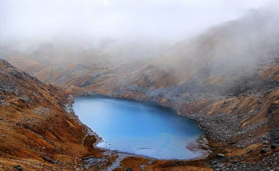
Vasuki Tal sits at 4,135 metres, eight kilometres above Kedarnath temple in Rudraprayag district. That figure comes from the Rudraprayag district administration and Incredible India, and it’s the one worth trusting. A few environmental surveys list the lake slightly higher, around 4,231 metres — probably a different reference point on the shoreline, not a different lake. The trail runs inside Kedarnath Wildlife Sanctuary. Not a national park. That’s a small distinction with a real consequence: it changes which permit you actually need, and most articles on this trek get it wrong.
Quick answer: Vasuki Tal is 8 km one way from Kedarnath, at 4,135 m. The trek is graded moderate to difficult by Uttarakhand Tourism’s own trek document, not simply “difficult,” and published duration estimates range from 5 to 8 hours for the return trip — plan for most of a day rather than a fixed number. May–June and September–October are the workable windows.
One naming mix-up is worth clearing early. Government wetland records call this lake “Basuki Tal” specifically to separate it from a much smaller, seasonal pond near the Gangotri glacier that also gets called Vasuki Tal by trekkers on that route. They’re not close to each other and not comparable treks. This guide is about the Kedarnath-side lake — the 8 km day trek most people mean when they search the name.
- Location: Kedarnath, Rudraprayag, Uttarakhand
- Altitude: 4,135 m (13,566 ft) per Rudraprayag district and Incredible India; some environmental records list 4,231 m
- Distance from Kedarnath: 8 km one way
- Protected area: Kedarnath Wildlife Sanctuary
- Difficulty: Moderate to difficult, per Uttarakhand Tourism’s trek documentation
- Best windows: May–June, September–October
- Kedarnath 2026 opening: 22 April 2026 (official)
- Kedarnath 2026 closing: not yet consistently confirmed on official sources at the time of writing — several travel sites cite 11 November, one cites late October. Check the official portal closer to your travel date rather than relying on any single figure here.
Where the Name Comes From
Hindu mythology ties the lake to Vasuki, the serpent king who wound around Mount Mandara during the churning of the cosmic ocean and is said to have done penance here. A separate tradition holds that Lord Vishnu bathed in the lake on Raksha Bandhan. Both are matters of belief, not verifiable history, and the article treats them that way rather than stating them as fact.
The basin is fringed with Brahma Kamal, the alpine flower found across the Himalaya roughly above 3,000 metres, generally flowering between July and September. That overlaps with the monsoon window this guide tells you to avoid for the trek itself — which is the actual trade-off, not a contradiction to smooth over. If you want to see the flower in bloom, you’re accepting more weather risk to do it.
The Route
Gaurikund is the roadhead. From there the trek to Kedarnath covers roughly 16–17 km — published figures from different government documents range from 15 to 18 km, so treat any single number as approximate. The Kedarnath temple itself sits close to 3,580 m.
From Kedarnath, the trail climbs toward Vasuki Top, opens onto views of the Chaukhamba massif and the Mandakini valley, then drops roughly a kilometre to the lake. Total distance from Kedarnath is 8 km one way — the most solidly verified number in this entire guide.
Full approach: Dehradun → Rishikesh → Rudraprayag → Guptkashi → Gaurikund → Kedarnath → Vasuki Top → Vasuki Tal.
Permit: What’s Actually Required
Skip whatever you’ve read elsewhere about a “National Park permit.” Vasuki Tal is inside Kedarnath Wildlife Sanctuary, managed by the Uttarakhand Forest Department’s Kedarnath Wildlife Division — a sanctuary, not a national park, and the paperwork is tied to that.
The Kedarnath Wildlife Division now runs bookings through its own portal, which handles trek and entry permits online with ID verification at the trailhead. That system is confirmed for several sanctuary treks out of Gopeshwar and Chopta. Whether it covers the Kedarnath–Vasuki Tal side the same way isn’t something this article can confirm with certainty — the Sonprayag forest office has historically issued entry permits for this route in person. Some operators quote a nominal fee, around ₹150 for Indian nationals and ₹600 for foreign nationals, but that figure comes from a trekking blog rather than an official rate card, so treat it as indicative and confirm the current amount locally before you go.
The practical instruction: check with the forest office at Sonprayag or Kedarnath, or call the Kedarnath Wildlife Division helpline, before you assume either the fee or the online-versus-in-person process.
Best Time to Visit
| Period | What actually happens |
|---|---|
| May – mid-June | Pre-monsoon window, generally stable, the season most trek operators recommend |
| Late June – August | Monsoon. Heavier rain, higher landslide risk on the Gaurikund–Kedarnath stretch |
| Mid-Sept – October | Post-monsoon clarity, colder nights, a real second option |
| November – April | Heavy snow closes the temple and makes the trek impractical; exact dates vary by year |
Kedarnath opened for 2026 on 22 April. If you’re planning a late-season attempt, don’t lock in a closing date from a blog post — confirm it through the official Uttarakhand Tourism registration portal or BKTC close to your travel date, since sources disagree on the exact 2026 closing day.
How to Reach Gaurikund
- By air: Jolly Grant Airport, Dehradun, is roughly 240–250 km from Kedarnath. Taxi is the only realistic option from there.
- By rail: Rishikesh and Haridwar are the nearest stations, both around 210–220 km from Gaurikund by road.
- By road: Shared taxis and buses run from Haridwar and Rishikesh to Sonprayag, then a shared jeep to Gaurikund. Private vehicles stop at Sonprayag.
- Gaurikund to Kedarnath: 16–17 km on foot, or a helicopter shuttle from Phata, Sirsi, or Guptkashi if you’d rather skip the walk.
What’s Near the Lake
Kedarnath Temple is the obvious anchor — one of the twelve Jyotirlingas, ancient, and by BKTC’s own description more than a thousand years old rather than tied to one exact century. Give darshan two to three hours before you start the trek.
Vasuki Top is the ridge you cross on the way up, and on a clear day the view of Chaukhamba rivals the lake itself. Chorabari Tal, also called Gandhi Sarovar, is a smaller glacial lake a few kilometres above Kedarnath, fed by the Chorabari glacier, and it sees far fewer visitors than the main temple. Bhairav Nath Temple, close to the main shrine, is considered Kedarnath’s protector in local tradition, and it’s the kind of stop most pilgrims skip simply because it isn’t the headline attraction.
Camping
Don’t assume you can pitch a tent at Vasuki Tal without asking first. The official Uttarakhand Tourism itinerary for this trek treats it as a day excursion from Kedarnath, with the overnight stay back at Kedarnath — not at the lake. If you’re set on camping, the only responsible path is confirming current rules directly with the Kedarnath Wildlife Division or a registered local operator before you carry a tent up there. Anyone who tells you camping is simply allowed, no questions asked, hasn’t checked recently.
Cost
Real numbers here are thin, and this article won’t invent them. A few things are worth knowing regardless: guide rates climb sharply in May and June when demand peaks, so agree a figure before you start walking. The forest permit fee, whatever it turns out to be at the office you visit, is a minor part of the total cost compared to a guide and any helicopter leg to Kedarnath. Helicopter fares from Phata, Sirsi, or Guptkashi change by season and operator — check heliyatra.irctc.co.in directly rather than trusting a fixed number from any blog, including this one.
Getting the Timing Right
Start early. Nobody enforces a 6 AM cutoff on this trek, but the return covers close to 16 km and mountain weather in the Mandakini valley turns fast in the afternoon. An early start buys you a margin, not a guarantee.
Turn back the moment you see thunderstorms, heavy cloud buildup, or a sharp drop in visibility — there’s no fixed hour when this risk switches on, so don’t wait for a clock to tell you it’s time to descend.
Mobile coverage is worth planning around rather than hoping for. On the main Kedarnath route, only Jio has been reported working reliably; other carriers go dark. Download offline maps before you leave Sonprayag and tell someone your return time.
Altitude and Health
Kedarnath itself sits close to 3,580 m, and Vasuki Tal is higher still at 4,135 m. Spending a night at Kedarnath before attempting the trek gives you some acclimatisation, particularly if you’ve come from low altitude — it doesn’t eliminate the risk of altitude illness, and nobody should treat one night as a guarantee.
Rapid ascent without time to adjust is what drives most altitude problems, not any single mistake in isolation. Severe headache, repeated vomiting, confusion, or trouble walking in a straight line are signs to stop climbing and head down, not push through.
If you have significant heart or lung disease, or hypertension that isn’t well controlled, talk to a doctor familiar with high-altitude travel before you commit to this trek. That’s a conversation to have in advance, not a blanket rule that rules out everyone with a blood pressure prescription.
What to Pack
- Layered warm clothing — near the lake, temperatures fall well below what you’d expect from a plains summer, even outside winter
- Trekking boots with ankle support; the terrain above Kedarnath is loose rock and moraine
- Trekking poles, especially for the descent from Vasuki Top
- Rain gear — afternoon showers happen even outside the monsoon
- Water and food for the full day; nothing is sold on the trail past Kedarnath
- A basic first-aid kit, including anything you’d need for altitude discomfort, chosen with your doctor’s input beforehand
- A headlamp with spare batteries, sunscreen, sunglasses, and a valid photo ID
- A power bank — there’s no charging point anywhere on the route
Frequently Asked Questions
Q1. What is the altitude of Vasuki Tal?
4,135 metres, per the Rudraprayag district administration and Incredible India. Some environmental survey documents list a slightly different figure, around 4,231 metres, likely from a different measurement point.
Q2. How far is Vasuki Tal from Kedarnath?
8 km one way. This is the most consistently verified fact across government and tourism sources.
Q3. Do I need a permit for the Vasuki Tal trek?
Yes — the route is inside Kedarnath Wildlife Sanctuary, and entry requires forest department clearance. Confirm the current process (online through the Kedarnath Wildlife Division portal, or in person at Sonprayag) before you travel, since this has reportedly changed in parts of the sanctuary.
Q4. Is the Vasuki Tal trek difficult?
Uttarakhand Tourism’s own trek documentation grades it moderate to difficult. Altitude, a steep final stretch, and loose terrain make it demanding regardless of the exact label.
Q5. How long does the trek take?
Published estimates range from 5 to 8 hours for the Kedarnath–Vasuki Tal–Kedarnath round trip. Treat it as most of a day rather than a fixed number.
Q6. Can beginners do this trek?
It’s not the ideal first high-altitude trek. Prior experience above 3,000 m and reasonable fitness matter more here than on the main Kedarnath pilgrimage route.
Q7. Is camping allowed at Vasuki Tal?
Don’t assume so. Official itineraries treat this as a single-day trip from Kedarnath. If you want to camp, confirm current permission with the Kedarnath Wildlife Division first.
Q8. Is there mobile network on the trail?
Coverage is patchy. Reports for the Kedarnath route specifically note that only Jio works reliably; other networks frequently have no signal at all.
Q9. When does Kedarnath open and close in 2026?
It opened 22 April 2026, officially confirmed. The 2026 closing date isn’t consistently confirmed across official sources as of this writing — check the Uttarakhand Tourism portal or BKTC before finalising a late-season trip.
Q10. What can be seen from Vasuki Top?
The Chaukhamba massif and the Mandakini valley, on a clear day about as good a view as the region offers.
The Short Version
Vasuki Tal is real, it’s 8 km from Kedarnath at 4,135 m, and it’s genuinely one of the quieter high-altitude trekking targets in the Kedarnath valley. Most of what trips people up isn’t the trail — it’s outdated blog claims about permits, fixed timings, and closing dates that were never officially confirmed in the first place. Check the permit situation directly with the Kedarnath Wildlife Division before you go, acclimatise at Kedarnath first, and don’t trust any single source — including this one — for a number as specific as a closing date or a permit fee without a second check closer to your travel date.
2 thoughts on “Vasuki Tal Trek: A Complete Guide to the Himalayan Lake”


Guide is required for this trek?
Please send your contact number . vasuki tal trek guide