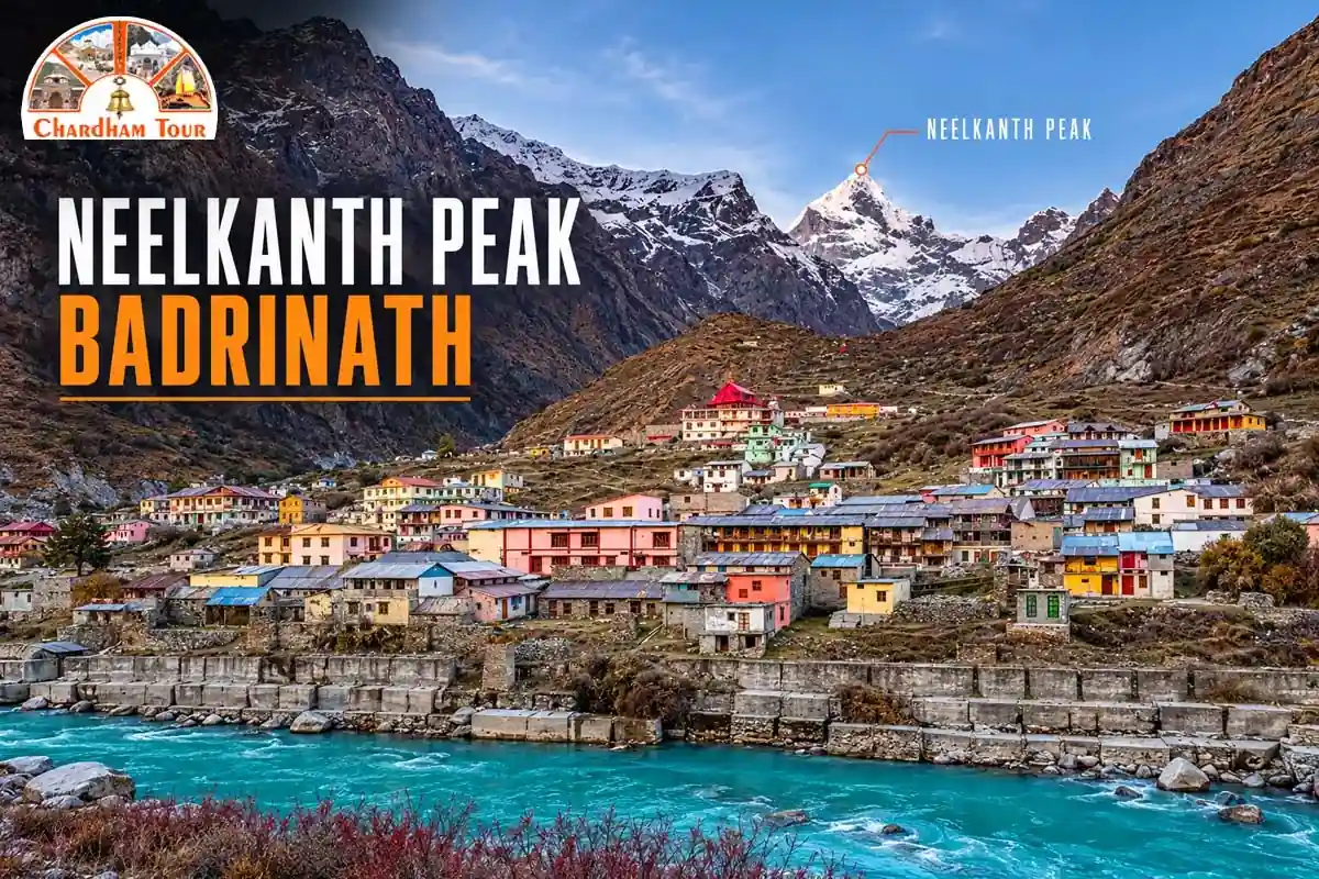
Stand in the Badrinath Temple courtyard at sunrise and Neelkanth Peak is the first thing to catch light. A pyramid of snow and rock, 6,596 metres up, sitting almost directly behind the shrine. Locals call it the Garhwal Queen. Frank Smythe, who saw it in 1931, called it second only to Siniolchu in Himalayan beauty — and he’d seen most of the range by then, so that’s not a throwaway compliment.
This is not a mountain you casually summit on a weekend trip. What most people actually do is trek to its base camp, get the close-up view, and turn around. Climbing it is a different undertaking entirely, one with a short and difficult history.
Quick answer: Neelkanth sits roughly 9–10 km from Badrinath at 6,596 m elevation (the Ministry of Tourism’s own site lists 6,507 m — the two figures disagree and neither has fully displaced the other). The base camp trek runs through Charan Paduka and is manageable in a long day for a fit hiker. Summiting the peak is technical mountaineering with only a handful of recorded ascents since 1974.
Height: Two Numbers, One Honest Answer
Every mountaineering record I checked — the Himalayan Journal, Wikipedia, the American Alpine Club’s ascent reports — lists Neelkanth at 6,596 m. That’s the figure climbers who’ve actually been on the mountain use. The government’s Incredible India page lists 6,507 m instead. I’m not going to pretend one of these is obviously correct and the other is a typo. Both are published by credible sources, and they simply don’t match. For everything else in this guide, I’m using 6,596 m, because that’s the number the people who climbed the thing agree on.
The peak rises 3,474 m above Badrinath itself, which sits at 3,133 m. That gap is why the summit dominates the skyline the way it does — you’re not looking at a distant range, you’re looking at something that towers directly over the town.
Why “Garhwal Queen”
Neelkanth means blue throat, one of Shiva’s names, tied to the story of him swallowing poison during the churning of the ocean to save the world. Local legend adds a specific twist to the geography here: a path is said to have once run directly between Kedarnath and Badrinath, until Shiva — angered by a priest’s misconduct — raised this mountain to block it. That’s belief, not history, and worth saying so plainly rather than dressing it up as fact.
The Garhwal Queen name is Smythe’s, from 1931, and it stuck because the shape genuinely resembles a figure seated in meditation from certain angles. Pilgrims who catch it lit gold at sunrise tend to take that as a good sign for the yatra ahead.
Climbing History: What Actually Happened
This is where a lot of travel sites get sloppy, so here’s the record straight, sourced from Himalayan Journal accounts and cross-checked against the American Alpine Club’s publications.
In 1961, an Indian expedition under Col. Narendra Kumar claimed the first ascent via the north face. The claim didn’t survive scrutiny — the Himalayan Club’s own reviewers found the route had been underestimated and concluded the team likely turned back well short of the top. That claim is now generally set aside.
The ascent everyone accepts happened on 3 June 1974. An Indo-Tibetan Border Police team led by S.P. Chamoli set out to climb the west ridge, couldn’t make it work, and switched to the north face instead. Sonam Pulzor, Kanhiya Lal, Dilip Singh, and Nima Dorje reached the summit. Seven earlier attempts, going back to the 1930s, had failed.
In 1993, a joint Army expedition — Indian, French, American, British, and Italian climbers — fixed nearly 4,000 metres of rope up the previously unclimbed North-East Ridge and put more than thirty people on the summit between 30 May and 2 June. That same year, separately, two British climbers attempted the West Ridge from the Panpatia Glacier side and had to retreat when one of them developed severe altitude sickness.
The West Ridge itself wasn’t climbed until 2000, when Martin Moran led a British team — John Leedale, Andy Nisbet, Jonathan Preston, Casper Venter — up a route graded D+/TD-, technical mixed climbing the whole way. As of that expedition’s own account, only three ascents of Neelkanth existed at all. A Slovenian team added a fourth the following years via the southwest face.
The takeaway: this mountain has resisted climbers for nearly a century, and it still has one of the shortest ascent lists of any Himalayan peak this well-known. Treat any claim of it being an easy or routine climb with suspicion.
The Base Camp Trek — Not the Same Thing as Climbing the Peak
Here’s the confusion that trips up most travel content on this topic: the “Neelkanth trek” tourists talk about and the technical climb described above are not the same activity, not the same risk, and not remotely the same skill level.
The trek starts in Badrinath and runs through Charan Paduka, about 3 km along a route where you’ll see what’s believed to be Lord Vishnu’s footprints and the Rishi Ganga falls. From there to the base camp, sources disagree on distance — Uttarakhand Tourism’s own expedition listing gives 6 km, while several trekking accounts describe closer to 9–10 km one-way, and at least one recent trekker’s video account puts the full round trip at 20–22 km in a single day. I’d rather tell you the numbers don’t agree than invent a clean total that sounds tidier than the reality on the ground.
Base camp altitude has the same problem: one government-linked source puts it at 3,850 m, trekking operators often say 4,270 m. Confirm the current route and camp location with a local guide before you go — don’t plan your day around a number pulled from a random blog.
From base camp, you get a close, unobstructed view of the north face. That’s the payoff, and it’s the point where almost everyone turns back.
Difficulty — Don’t Undersell This
I’m not going to call this route beginner-friendly, and I’d push back on any guide that does. Official documentation classifies the Neelkanth approach as high-risk, and it sits within the Nanda Devi Biosphere Reserve’s expedition framework, not its casual sightseeing one. The terrain past Charan Paduka gets rougher fast, the altitude is real, and weather at this elevation turns without much warning.
If you’re reasonably fit and go with a local guide, the base camp trek is achievable. It is not, however, a stroll. Anyone telling you it’s suitable for casual first-time trekkers with no altitude experience is giving you bad information.
Permits and Registration — Two Separate Things
Every pilgrim visiting Badrinath needs Char Dham e-registration. That’s mandatory, it’s free, and you do it through the official Uttarakhand government portal — registrationandtouristcare.uk.gov.in — or at offline counters in Haridwar and Rishikesh. Register a few weeks ahead if you’re going in peak season; June and July fill up.
That registration covers your entry to Badrinath. It does not automatically cover route access for the Neelkanth trail, which falls under separate forest and protected-area rules given its location inside the biosphere reserve. Don’t assume one form clears you for both. Check locally before you head up.
Best Time to Go
June through September is the standard window, overlapping the main Badrinath yatra season, and it’s when I’d point most people. July brings the heaviest monsoon activity and the highest landslide risk on the approach roads — worth avoiding if you can shift your dates. Winter is off the table entirely; the temple closes and the trail is buried in snow.
Badrinath’s 2026 Kapat opened on 23 April and the yatra has been running since. The closing date, expected around 13 November, gets confirmed officially on Vijayadashami in October — check the Badrinath-Kedarnath Temple Committee’s site closer to the date rather than treating 13 November as locked in.
Getting to Badrinath
The nearest airport is Jolly Grant in Dehradun, roughly 315–320 km away. The nearest railhead is Rishikesh, around 295–300 km out. Buses and shared taxis run through the yatra season, and the drive itself takes something like 10–12 hours depending on road and weather conditions on any given day — mountain roads don’t run on a fixed schedule. Most people break the trip overnight at Joshimath or Pipalkoti rather than pushing straight through.
Mistakes People Actually Make Here
Starting the trek too late is the biggest one — mountain visibility tends to worsen as the day goes on, so an early start matters more than people expect. Skipping acclimatization is the second: Badrinath itself sits above 3,100 m, and jumping straight into a full trekking day without adjusting first is asking for altitude trouble. The third is underestimating the stretch past Charan Paduka — it looks short on a map and feels considerably longer on the ground. And the fourth, which this whole guide exists partly to correct, is treating the base camp trek and a summit attempt as versions of the same activity when they’re not.
What to Carry
Water, first — carry everything you’ll need for the day and don’t count on finding a source along the trail. Warm layers, since wind at altitude cuts through faster than the daytime temperature suggests. Sturdy footwear, a raincoat, and enough energy food (dry fruit, biscuits, something with sugar in it) to get through a long day without a shop in sight, because there isn’t one.
FAQs
How tall is Neelkanth Peak?
6,596 m according to mountaineering records; the Ministry of Tourism’s own page lists 6,507 m. The two don’t agree.
How far is Neelkanth from Badrinath?
Roughly 9–10 km depending on which reference point you use.
Is the Neelkanth trek suitable for beginners?
Not without qualification. It’s demanding past Charan Paduka, and official documentation treats the route as high-risk. Go with a local guide, and don’t attempt it as your first high-altitude trek.
When was Neelkanth first climbed?
3 June 1974, by an ITBP team led by S.P. Chamoli, via the north face. An earlier 1961 claim was later disputed and set aside.
Who made the first ascent of the West Ridge?
Martin Moran’s British team, in 2000 — the fourth ascent of the mountain overall at that point.
Why is Neelkanth called the Garhwal Queen?
Frank Smythe gave it the name in 1931, rating it second only to Siniolchu for beauty in the whole Himalayan range.
Do I need a permit for the base camp trek?
Char Dham registration covers your entry to Badrinath, but it isn’t automatically route access for the Neelkanth trail, which sits inside the Nanda Devi Biosphere Reserve’s regulated zone. Confirm current requirements locally.
Where do I register for the Char Dham Yatra?
registrationandtouristcare.uk.gov.in, or at offline counters in Haridwar and Rishikesh. It’s free.
What’s the best time to see Neelkanth clearly?
Early morning, June through September, before cloud typically builds up later in the day.
How high is the Neelkanth Base Camp?
Sources disagree — 3,850 m by one government-linked source, 4,270 m by several trekking operators. Confirm current camp location before relying on either figure.
Is Badrinath open right now?
Yes — the 2026 Kapat opened 23 April and the yatra is ongoing. Closing is expected around 13 November, pending official confirmation in October.
Bottom Line
Neelkanth earned its reputation the hard way — nearly a century of failed attempts before anyone stood on top, and only a handful of successful ascents since. What you can do without a mountaineering résumé is the base camp trek, and even that deserves more respect than most trip-planning content gives it. Go in June through September, register for Badrinath ahead of time, confirm the current trail conditions with someone local rather than a blog, and start early. The sunrise view is exactly what people say it is. Just don’t confuse getting there with climbing it.