
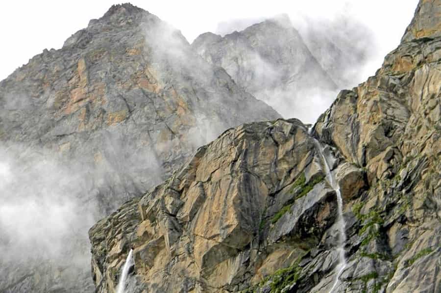
Vasudhara Falls is a high-altitude waterfall near Badrinath, reached by a trek from Mana Village. Most published sources put the drop at 400 feet (122m). The Chamoli district government’s own tourism page lists it differently — 145m. Neither is a typo; they’re just two different measurements circulating for years. We’re giving you both instead of pretending there’s one clean number. It’s one of the more rewarding short treks in the Badrinath sightseeing circuit — no ropes or technical climbing, but the altitude makes the last stretch harder than the distance on paper suggests.
Quick Answer: Vasudhara Falls is commonly listed as 9 km from Badrinath — 3 km by road to Mana Village, then a trek most sources put at 6 km (the Chamoli government site says 5 km). Budget 5–6 hours round trip. Go mid-May to June or September to October — after the Char Dham Yatra opens and before winter shuts the route again.
From a distance, the water looks like a stream of milk pouring off the cliff. Chaukhamba, Neelkanth, and Balakun peaks sit behind it, and the trail runs through high-altitude terrain with river valley views most of the way. There’s a local belief — nothing you’ll find in any government document, just something people here say — that the waterfall’s spray turns away from those who are impure at heart. It’s tied to the Mahabharata lore of this region, where the Pandava brothers are said to have passed through on their final journey.
- Location: Commonly listed as 9 km from Badrinath (3 km by road to Mana, then the trek)
- Height: 400 feet (122m) per most travel sources; the Chamoli district government site says 145m
- Altitude at the falls: Roughly 12,000 feet
- Legend: Linked to the Pandavas’ route toward Swargarohini
- Difficulty: Easy-to-moderate; steep only in the final stretch
The Climate of the Region
Because the falls sit at high altitude, expect cool, breezy weather even under a clear sun, with fog rolling in and out through the day. Evenings turn cold fast, so carry a windproof jacket even if you start the trek in daylight warmth. Weather can shift within an hour here — a sunny morning doesn’t guarantee a clear afternoon.
Trekking Trail: Distance, Difficulty & Permit
The trek starts from Mana Village, past Bhim Pul. Most sources call it 6 km one way; the Chamoli government’s own page says 5 km. Take your pick — either way it’s a half-day commitment, not a stroll. The path stays walkable for the first stretch out of Mana, then gets rockier and steeper the closer you get to the falls, with a real climb right at the end.
Budget around 5–6 hours for the full round trip, including rest breaks — this isn’t a rushed half-day walk. Don’t count on shops or water points along the trail; carry enough food and water to cover the whole day yourself.
Permit and ID rules: Mana sits close to the Indo-Tibetan border, and there’s an ITBP checkpost on the road at Mana. Indian citizens don’t need a formal permit for Vasudhara Falls itself, but carry a government photo ID — it gets checked. Foreign nationals should expect tighter requirements in this belt; the exact clearance needed for the falls specifically wasn’t something we could pin down to one clean rule, so check with the SDM office in Joshimath or a registered operator before you go rather than assuming. Beyond Vasudhara — toward Mana Pass or Deo Tal — is a different story: that’s Army/ITBP-controlled territory, and you need an Inner Line Permit from the SDM Joshimath plus an Army/ITBP NOC to go there at all. Casual trekkers stop at Vasudhara.
Places to Visit Near Vasudhara Falls
Badrinath Temple
The starting point for most visitors, this temple dedicated to Lord Badri Vishal (Vishnu) sits at about 3,133 metres. Tradition credits Adi Shankaracharya with establishing it in the 8th century. Singh Dwara, the main gate, is the temple’s most photographed feature.
Mana Village
Often called India’s last (or “first,” post-2022 rebranding) village before the Tibet border, Mana lies on the Alaknanda’s banks, about 3 km from Badrinath. It’s where the Mana–Vasudhara trek begins, and it’s also where devotees perform Shraddha rituals for departed ancestors.
Tapt Kund
A natural hot spring near the temple. Most sources put the water around 45°C year-round, though a few give a range up to 55°C — either way, it’s warm enough that locals still find it remarkable given how cold everything around it gets. It’s traditionally believed to have healing properties; treat that as belief, not medical fact.
How to Reach Vasudhara Falls
- By Road: Badrinath connects by motorable road to Rishikesh, Haridwar, Rudraprayag, Karnaprayag, and Chamoli. From Delhi’s ISBT Kashmere Gate, regular buses run to Haridwar/Rishikesh, from where shared taxis or buses continue toward Badrinath. Note that the road passes landslide-prone stretches near Lambagad and Hanuman Chatti, especially during monsoon — build buffer days into your plan.
- By Rail: Rishikesh Railway Station, about 294 km away, is the nearest major railhead. From there, hire a taxi or catch a bus toward Badrinath.
- By Air: Jolly Grant Airport, Dehradun, roughly 311 km from Badrinath, has regular flights from Delhi. Taxis are available outside the airport for the onward journey.
Best Time to Visit Vasudhara Falls
Vasudhara Falls is generally visited during the Badrinath–Mana travel season — the temple opens around late April (23 April in 2026) and closes around mid-to-late November. That said, the temple opening doesn’t automatically mean the trail is clear; snow, weather and trail conditions are a separate call, so check locally before you set out. Within the season:
- Mid-May to June: Best overall — snowmelt keeps the falls at full flow, and trails are clear.
- September to October: Cooler, drier, with the best mountain visibility.
- July–August (monsoon): Avoid if possible. Heavy rain increases landslide risk on the Joshimath–Badrinath highway, and the trekking trail gets slippery.
- November onward: The region starts getting snowbound and the temple closes for winter — the falls become inaccessible until the next season.
Common Mistakes to Avoid
- Starting the trek too late in the day — afternoon fog and cold can catch you off guard on the way back.
- Skipping acclimatization — spending at least one night in Badrinath before the trek helps at this altitude.
- Not carrying enough water — there’s nothing to buy en route.
- Ignoring footwear — the last stretch is loose rock and needs proper grip, not sandals.
Pro Tips
- Spend at least one night in Badrinath before the trek. It helps with acclimatization at this altitude, even for fit trekkers.
- Start by 7–8 AM. You want daylight in hand for the return, not just the way up.
- Know the signs of altitude sickness — headache, nausea, dizziness that gets worse instead of better. Turn back if that happens; don’t push through it.
- Check the Uttarakhand PWD road status a day before travelling during monsoon months.
FAQs
How far is Vasudhara Falls from Badrinath?
Commonly listed as 9 km — 3 km by road to Mana Village, then a trek most sources put at 6 km (the Chamoli district government page says 5 km). Either way, plan for a half-day trek, not a quick walk.
Is a permit required to trek to Vasudhara Falls?
Indian citizens need only a government photo ID for the ITBP checkpost at Mana. Foreign nationals require a pre-arranged Inner Line Permit.
How long does the Vasudhara Falls trek take?
Most trekkers complete the round trip in 5–6 hours, including rest stops.
Is the Vasudhara Falls trek difficult?
It’s easy-to-moderate — the first half is gentle, but the final stretch near the falls is steep and rocky.
What is the best time to visit Vasudhara Falls?
Mid-May to June and September to October, when Badrinath is open and the trail is clear.
Is Vasudhara Falls open in the monsoon?
The area technically stays open, but heavy rain brings landslide risk on the approach road — better to avoid July–August.
Can senior citizens attempt this trek?
The altitude and uneven terrain make it demanding, not casual. Assess your own fitness honestly, and if you have any health concerns, check with a doctor before attempting a high-altitude trek like this one.
Are there shops or food stalls on the trekking trail?
No — carry your own water and snacks; there’s nothing available between Mana and the falls.
Where can I stay near Vasudhara Falls?
Mana has no hotels; stay in Badrinath, about 3 km away, and do the trek as a day trip.
What is the legend behind Vasudhara Falls?
Locals believe the waterfall’s spray does not touch those who are impure at heart, and the site is linked to the Pandavas’ final journey in the Mahabharata.
Conclusion
Vasudhara Falls rewards the effort of a 6 km trek with one of the most striking high-altitude views near Badrinath — glacial water dropping 400 feet against a wall of Himalayan peaks. Time it for mid-May–June or September–October, carry your ID for the ITBP checkpost, start early, and pace yourself for the altitude. Combined with Badrinath Temple, Mana Village, and Tapt Kund, it makes for a full and memorable day around one of the holiest corners of Uttarakhand.
One thought on “Vasudhara Waterfalls- The Mystical Falls Near Badrinath Dham”


ami visite korechi