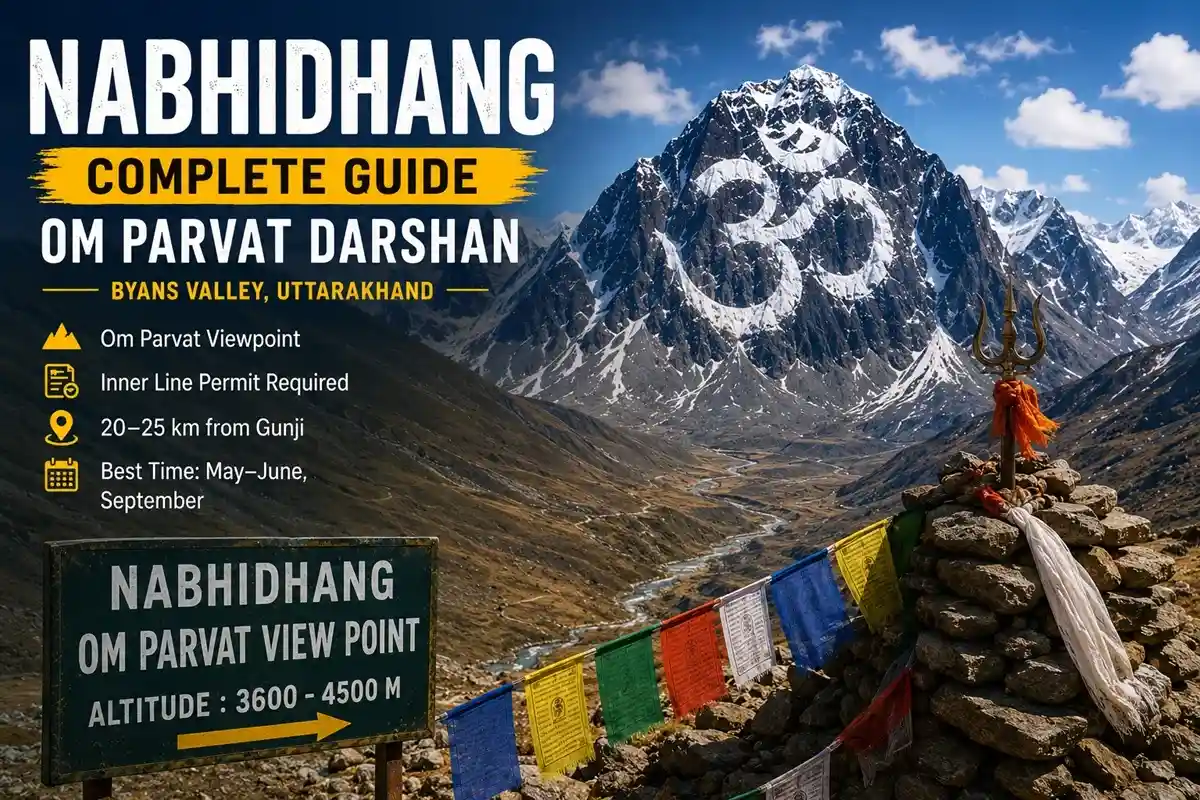
Nabhidhang is the viewpoint every Om Parvat pilgrim eventually asks about — how far it is from Gunji, whether it needs a trek, and what the altitude actually feels like. It’s a high-altitude spot in Pithoragarh district’s Byans Valley, reached by 4×4 from Gunji, where pilgrims get their clearest darshan of the natural “Om” pattern on Om Parvat.
Unlike the Adi Kailash trek, Nabhidhang needs almost no walking — but the altitude and remoteness still demand real preparation. Here’s a fact-checked, ground-level guide to reaching it in 2026.
| In Short:
Nabhidhang is a vehicle-accessible viewpoint in Pithoragarh’s Byans Valley, roughly 20–25 km from Gunji by 4×4. It’s the main darshan point for Om Parvat (peak elevation 5,590 m per Wikipedia), needs the same Inner Line Permit as Adi Kailash, and is best visited May–June or September for the clearest “Om” view. |
Nabhidhang at a Glance: Quick Facts
| Attribute | Details |
| State / District | Uttarakhand / Pithoragarh |
| Region | Byans Valley, Kumaon Himalaya |
| Nabhidhang altitude | Reported ~3,600–4,500 m (sources vary widely) |
| Om Parvat peak height | 5,590 m / 18,340 ft (Wikipedia) |
| Permit required | Yes — Inner Line Permit (shared with Adi Kailash) |
| Nearest base village | Gunji (~20–25 km) |
| Road condition | Off-road, 4×4 only, glacier-fed stream crossings |
| Best months | May, June, September |
| Accommodation on-site | None — base at Gunji or Nabi |
| Mobile network | Patchy to absent — do not rely on it |
What Is Nabhidhang and Why Do Pilgrims Go There?
Nabhidhang is a high-altitude viewpoint in the Byans Valley, near the India-Tibet-Nepal tri-junction region of Pithoragarh district. It’s the closest and clearest spot from which pilgrims can view Om Parvat — the sacred peak where snow naturally settles into an “ॐ” shape on bare rock.
Om Parvat’s peak elevation is 5,590 m (18,340 ft) per Wikipedia — worth noting since many travel sites mistakenly quote Adi Kailash’s much higher ~6,191 m figure for Om Parvat instead. Nobody climbs it for darshan; pilgrims simply stand at Nabhidhang, offer prayers, and photograph the formation when weather permits.
Nabhidhang Altitude and Key Distances
Nabhidhang’s own altitude is reported very inconsistently — anywhere from about 3,600 m to 4,500 m depending on the source, since there’s no single official survey figure widely cited. Treat the numbers below as planning estimates.
| Location | Approx. Height / Distance |
| Dharchula | ~915 m |
| Gunji (base village) | ~3,200 m |
| Kalapani (en route) | ~3,600 m |
| Nabhidhang viewpoint | ~3,600–4,500 m (varies by source) |
| Om Parvat peak (not climbed) | 5,590 m |
| Gunji to Nabhidhang distance | ~20–25 km, 1.5–2 hrs by 4×4 |
How to Reach Nabhidhang from Gunji
The drive runs Gunji to Kalapani to Nabhidhang — about 20–25 km on an off-road, glacier-fed mountain track. Only KMVN or registered tour-operator 4×4 vehicles (typically Bolero Campers) are currently permitted on this stretch; private vehicles aren’t allowed beyond Dharchula.
Kalapani, about 20 km from Gunji, is worth the stop for the Kali Mata Mandir and the Ved Vyas Gufa, the cave where Sage Ved Vyas is traditionally believed to have composed the Mahabharata. Sheshnag Parvat, a ridge resembling a coiled serpent, is visible en route. Local drivers usually recommend the Nabhidhang run only after a full acclimatisation night at Gunji.
Nabhidhang vs Jyolingkong: Don’t Confuse the Two
Pilgrims often mix up Nabhidhang with Jyolingkong, the base point for Adi Kailash darshan at Parvati Sarovar (see our full Kuti Village and Adi Kailash Yatra guides). Both are reached from Gunji, but they’re separate excursions on separate days — Jyolingkong involves a short trek for Adi Kailash darshan, while Nabhidhang is purely vehicle-based and exists only for viewing Om Parvat.
Permits and Registration
Nabhidhang falls inside the same ITBP-patrolled restricted zone as Adi Kailash. As per SDM Dharchula and Uttarakhand Tourism guidelines, the standard Inner Line Permit (ILP) already covers Nabhidhang — no separate permit is needed if you’re covered for the Adi Kailash Yatra. Foreign nationals face significant additional restrictions in this border zone and should confirm current Ministry of Home Affairs rules well ahead of travel. Permit fees change periodically, so confirm current charges with SDM Dharchula before you go.
Best Time to Visit Nabhidhang for Om Parvat Darshan
May, June, and September typically give the clearest snow-and-rock contrast on Om Parvat. Cloud cover is common by early afternoon, so many itineraries build in a second Nabhidhang stop on the return leg if the first darshan gets blocked. Avoid the route entirely during monsoon — the glacier-fed streams along the track become genuinely unsafe to cross.
Altitude Sickness and Acclimatisation
Nabhidhang sits well above 3,500 m, within the range where Acute Mountain Sickness (AMS) becomes a real risk. Advisories linked to ITBP medical staff recommend at least one full overnight stay at Gunji before attempting the drive — never go straight from Dharchula to Nabhidhang in a single day. Watch for headaches, breathlessness, or nausea, and descend if symptoms worsen.
What to Expect at Nabhidhang
There’s very little infrastructure here — no market, limited shelter, and biting wind even in peak season. Most pilgrims spend 30–45 minutes at the viewpoint before heading back to Gunji.
- Carry your own water, snacks, and warm layers — nothing is sold on-site.
- Mobile network is patchy to absent at Nabhidhang itself — don’t rely on it.
- Toilets are basic to non-existent; plan accordingly before leaving Gunji.
- Best photography light is sunrise to around 10 a.m., before afternoon cloud builds up.
Accommodation Near Nabhidhang
There’s no overnight stay at Nabhidhang itself — pilgrims base themselves at Gunji or nearby Nabi village, in KMVN guest houses or local homestays, and do the Om Parvat run as a same-day round trip.
Approximate Budget for the Nabhidhang Trip
These are rough, per-person, indicative-only figures on top of your main Adi Kailash Yatra package — confirm current rates with your operator.
| Expense head | Approximate cost (indicative) |
| ILP / permit fee | Confirm current charges with SDM Dharchula |
| 4×4 hire, Gunji–Nabhidhang return | ₹2,500–4,500 per vehicle (shared cost) |
| Extra night at Gunji, if needed | ₹1,000–2,000 |
Latest 2026 Updates
- Gunji has seen new investment under the government’s Vibrant Villages Programme, including road upgrades and a growing homestay network.
- Limited, seasonal helicopter connectivity to Gunji has been introduced under the same programme — this is not a routine tourist shuttle like Kedarnath’s HeliYatra, so confirm current availability directly.
- BRO continues road maintenance on the Gunji–Nabhidhang stretch; landslide-related delays remain common after heavy rain.
Who Should Visit Nabhidhang
- Families and senior citizens: manageable, since it’s vehicle-based with almost no trekking, though altitude prep still matters.
- Photographers: best chance of a clear Om Parvat shot in May, June, or September, ideally before mid-morning.
- Anyone combining it with Adi Kailash: most itineraries cover both from the same Gunji base.
- Not ideal for: travellers with severe heart or lung conditions, given the altitude and remoteness.
Key Takeaways
- Nabhidhang’s altitude is reported anywhere from ~3,600–4,500 m; treat exact figures cautiously.
- No real trekking is needed — this is a vehicle-based darshan point for Om Parvat (5,590 m).
- Same Inner Line Permit as Adi Kailash; no separate registration required.
- Best visited May–June or September; always acclimatise at Gunji first.
FAQs
What is the Nabhidhang Om Parvat distance from Gunji?
About 20–25 km one-way, roughly 1.5–2 hours by 4×4 depending on road conditions.
How to reach Nabhidhang from Dharchula?
Drive to Gunji first (about 70 km), stay overnight, then take a registered 4×4 to Nabhidhang the next day.
What is the Nabhidhang altitude?
Reported anywhere from about 3,600 m to 4,500 m — sources disagree significantly, so treat it as approximate.
Do I need a separate permit for Nabhidhang?
No — the same Inner Line Permit used for Adi Kailash covers Nabhidhang and Om Parvat darshan.
Is trekking required to reach Nabhidhang?
No. It’s vehicle-accessible, with only a short 100–200 m walk to the viewpoint.
What is the best time to visit Nabhidhang?
May, June, and September offer the clearest views of the Om Parvat snow formation.
Is there accommodation at Nabhidhang?
No. Pilgrims stay at Gunji or Nabi and visit Nabhidhang as a day trip.
Can private vehicles go to Nabhidhang?
No — only KMVN or registered tour-operator 4×4 vehicles are currently allowed beyond Dharchula.
Is mobile network available at Nabhidhang?
Coverage is patchy to absent at the viewpoint — don’t rely on it for emergencies.
Can Om Parvat be seen if it’s cloudy at Nabhidhang?
Not clearly — many pilgrims plan a second visit on the return leg in case of cloud cover.
Final Word
Nabhidhang is one of the easiest high-altitude darshan points in the Himalayas to physically reach, since it needs a jeep ride rather than a trek. But the altitude, remoteness, and permit requirements are just as real as anywhere else on the Adi Kailash route.
Plan an acclimatisation night at Gunji, check the weather before you commit to the drive, and treat this Om Parvat viewpoint with the same respect you’d give any high Himalayan pilgrimage.