The Adi Kailash Yatra route map covers one of the most geographically layered pilgrimage routes in India — beginning at Kathgodam Railway Station in the Kumaon foothills and climbing to the sacred Jyolingkong basin at ~4,572 m in the Pithoragarh district, on the border of Uttarakhand’s restricted zone near Tibet.
Until 2019, the Adi Kailash route required a trek of approximately 250 km from Dharchula. The BRO (Border Roads Organisation) has since constructed a motorable road all the way to Jyolingkong — making this largely a vehicle-based pilgrimage with optional short walks at specific sacred sites. This transformation makes the Adi Kailash road map significantly more accessible for senior citizens, families, and first-time high-altitude pilgrims.
This guide maps every significant segment of the Adi Kailash Yatra route stage by stage — distances, altitudes, road conditions, key villages, checkpoints, and the Om Parvat branch route from Gunji to Nabhidhang.
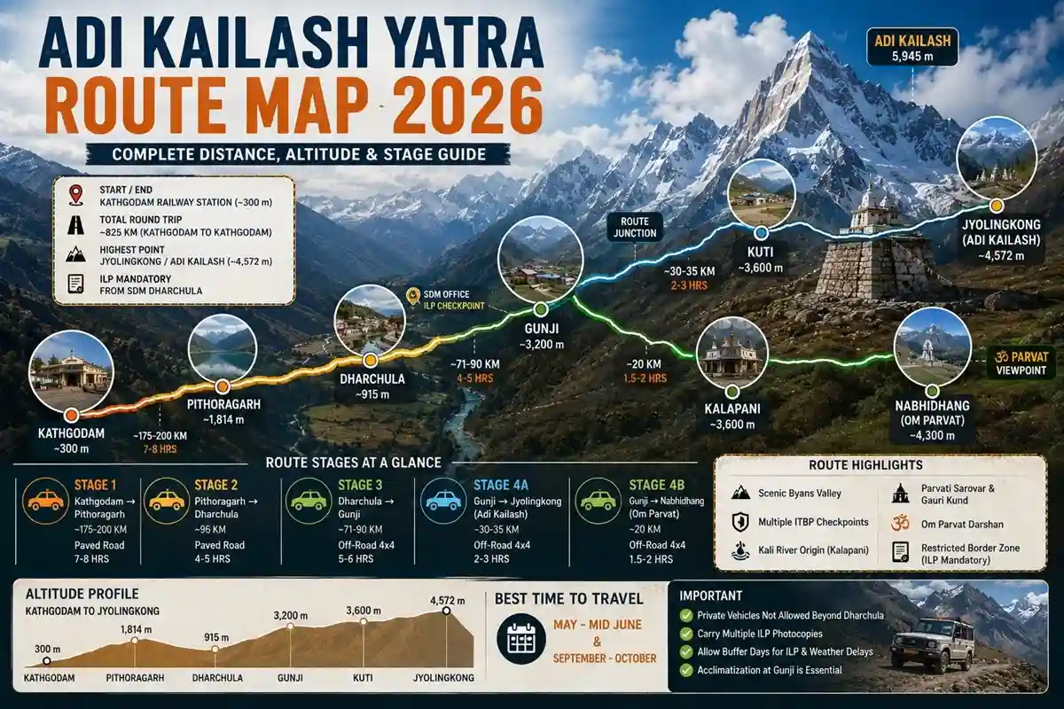
Complete Adi Kailash Yatra Route — Distances and Altitudes
| Stage | From → To | Distance | Altitude Range | Road Type | Drive Time |
| Stage 1 | Kathgodam → Pithoragarh | ~175–200 km | ~300 m → ~1,814 m | Paved state highway via Bhimtal, Almora | Approx. 7–8 hrs |
| Stage 2 | Pithoragarh → Dharchula | ~96 km | ~1,814 m → ~915 m | Paved mountain road (Kali River valley descent) | Approx. 4–5 hrs |
| Stage 3 | Dharchula → Gunji | ~71–90 km | ~915 m → ~3,200 m | Off-road mountain track — 4×4 mandatory | Approx. 5–6 hrs |
| Stage 4A | Gunji → Jyolingkong (Adi Kailash) | ~30–35 km | ~3,200 m → ~4,572 m | Off-road 4×4; final section vehicle-accessible | Approx. 2–3 hrs |
| Stage 4B | Gunji → Nabhidhang (Om Parvat) | ~20 km | ~3,200 m → ~4,300 m | Off-road 4×4; vehicle-accessible viewpoint | Approx. 1.5–2 hrs |
| Return | Gunji → Dharchula → Didihat | ~100–120 km | ~3,200 m → ~1,500 m | Same off-road track reverse | Approx. 4–6 hrs |
| Return | Didihat → Bhimtal → Kathgodam | ~330–370 km | ~1,500 m → ~300 m | Paved mountain/state roads via Patal Bhuvaneshwar | Approx. 10–12 hrs |
📌 All distances and times are approximate. Road conditions beyond Dharchula are unpredictable — actual times can be significantly longer due to weather, BRO road maintenance, or landslides. Always plan buffer time on the Dharchula–Gunji–Jyolingkong sections.
Stage 1 — Kathgodam to Pithoragarh (~175–200 km | Approx. 7–8 Hours)
Kathgodam → Bhimtal → Almora → Pithoragarh ~300 m → ~1,814 m | Paved road | State highway
This is the opening chapter of the Adi Kailash Yatra route. From Kathgodam Railway Station, the road climbs steadily through the Kumaon foothills toward Pithoragarh — the administrative headquarters of the border district and the last major city before the restricted zone begins.
The road passes through Bhowali (fruit orchards, government sanatorium), Bhimtal (lake town, 1,370 m), and Almora (historic hill town, 1,638 m) before the final push into Pithoragarh at ~1,814 m.
Key spiritual stops en route: Kainchi Dham (Neem Karoli Baba Ashram, between Bhimtal and Almora), Chitai Golu Devta Temple (12th-century God of Justice), and Jageshwar Dham (124 ASI-protected ancient Shiva temples in a deodar forest valley).
Road condition: Well-paved state highway for this entire section. Standard vehicles can handle this route without difficulty. Traffic is moderate and road quality is maintained.
- Suggested Tour: Adi Kailash and OM Parvat Yatra from Delhi
Stage 2 — Pithoragarh to Dharchula (~96 km | Approx. 4–5 Hours)
Pithoragarh → Jauljibi → Dharchula ~1,814 m → ~915 m | Paved mountain road | Descends into Kali River valley
The road descends from Pithoragarh’s height into the Kali River valley, following the river toward Dharchula. This section passes through Jauljibi — the confluence of the Gori Ganga and Kali (Mahakali) rivers — one of the significant river meeting points in Uttarakhand.
Dharchula (~915 m) sits in a narrow river valley on the India-Nepal border. The Kali River runs between Indian Dharchula and Nepali Darchula — you can see Nepal from the town centre.
What to do in Dharchula: This is where all permit formalities occur. The SDM (Sub-Divisional Magistrate) office issues the Inner Line Permit (ILP) — mandatory for all Indian citizens before proceeding. Online pre-registration at pass.pithoragarh.online is available; physical collection at SDM office remains mandatory as of 2026.
Practical: Last reliable ATM, last pharmacy, last mobile signal (Airtel/BSNL/Jio), and last bank on the route are all in Dharchula. Beyond Dharchula, none of these are available. Withdraw sufficient cash and stock final supplies here.
📌 ILP fee: approximately ₹200 per person. ILP must be presented at approximately 10 ITBP (Indo-Tibetan Border Police) checkpoints on the route beyond Dharchula. Carry multiple photocopies.
Stage 3 — Dharchula to Gunji (~71–90 km | Approx. 5–6 Hours) — The Critical Transition
Dharchula → Tawaghat → Budhi → Garbyang → Napalchu → Gunji ~915 m → ~3,200 m | Off-road 4×4 | Restricted zone begins
This is the most demanding road section of the entire Adi Kailash trek route. The paved road ends at Dharchula. From here, the 4×4 route climbs through the Byans Valley (Vyas Valley) along the Kali River, passing through remote Himalayan villages and multiple ITBP checkpoints.
Key villages on this stretch: Tawaghat (river confluence), Budhi (basic facilities), Chialekh Valley (high alpine meadow — one of the most scenic stretches), Garbyang (Rung community architecture, the ‘Sinking Village’), Napalchu (quiet Himalayan hamlet).
Road condition: Narrow, rocky, unpaved mountain track. Private vehicles are NOT permitted on this section — only KMVN-operated or registered tour operator 4×4 vehicles (typically Mahindra Bolero Camper) are allowed. This is a legal requirement enforced at Dharchula checkpoint.
Altitude gain: From Dharchula (~915 m) to Gunji (~3,200 m) is a gain of approximately 2,285 m — all in approximately 5–6 hours. This rapid ascent is the primary cause of AMS on the Adi Kailash route. Mild headache or reduced appetite on arrival at Gunji is expected and normal.
⚠️ Do NOT proceed from Gunji to Jyolingkong on the same day you arrive from Dharchula. A minimum of one night (ideally two) at Gunji for acclimatization is mandatory. Arriving at 4,572 m without adequate acclimatization significantly increases AMS risk in this restricted zone with no hospital access.
Gunji — The Route Junction for Both Sacred Peaks
Gunji Village (~3,200 m) is the single most important logistical point on the Adi Kailash Yatra route map. It is where the road forks into two branches — and where all permits are verified at the ITBP checkpoint.
From Gunji, the route divides:
- Left branch (northeast): → Kuti Village (~3,600 m) → Jyolingkong (~4,572 m) — Adi Kailash darshan
- Right branch (northwest): → Kalapani → Nabhidhang (~4,300 m) — Om Parvat darshan
Most standard itineraries visit both on separate days from a Gunji base. The Jyolingkong branch is typically done first — after acclimatization at Gunji — and the Nabhidhang branch on the return leg.
📌 Gunji is also home to a Nabi village (sometimes referred to as Nabi/Napalchu in older guides). The Finding Shiva community village at Nabi offers the only reliable Wi-Fi access point deep on this route.
Stage 4A — Gunji to Jyolingkong — Adi Kailash Branch (~30–35 km | Approx. 2–3 Hours)
Gunji → Kuti Village → Jyolingkong (Adi Kailash Base) ~3,200 m → ~4,572 m | Off-road 4×4 | Restricted zone
From Gunji, the 4×4 route continues northeast toward Jyolingkong — the meadow at the base of Adi Kailash. The road passes through Kuti Village (~3,600 m) — the last inhabited village before Jyolingkong.
Kuti Village holds historical significance: named in local tradition after Kunti (mother of the Pandavas). The ruins known as Pandav Kila are located here. A rest and lunch stop at Kuti is commonly built into itineraries — it provides a natural acclimatization pause before the final ascent to Jyolingkong.
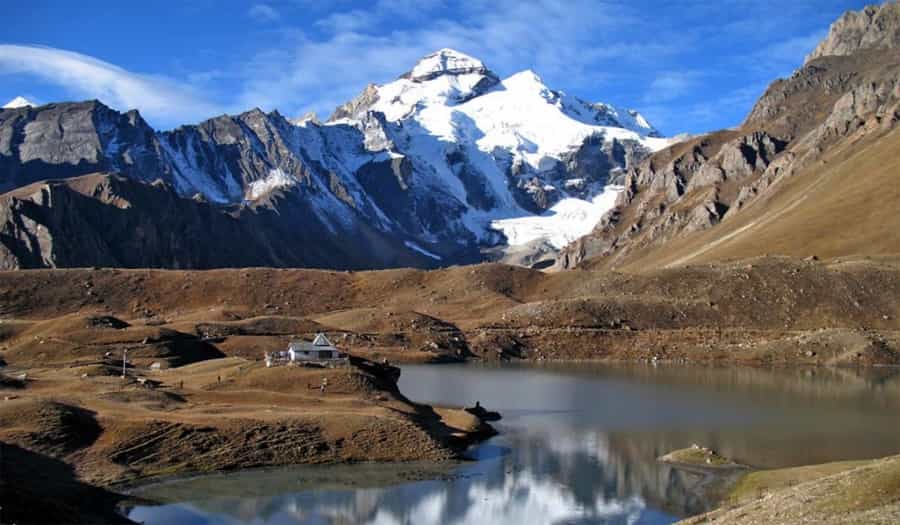
Jyolingkong (~4,572 m) is the spiritual endpoint — where the pyramidal peak of Adi Kailash (5,945 m) rises above the valley floor. The Shiva-Parvati Temple, Parvati Sarovar (sacred glacial lake), and the parikrama path are all within this basin.
Trekking at Jyolingkong: Vehicles reach the base. From there: 2 km optional parikrama of Parvati Sarovar (flat ground, moderate). Gauri Kund is 3–4 km from Jyolingkong on rocky but non-technical terrain. No technical climbing required for any site in this basin.
📌 Although the road is now motorable to Jyolingkong, vehicles are not permitted beyond the base parking area to preserve the sanctity of the site. The final approach to Parvati Sarovar and the temple is on foot — approximately 15–20 minutes of flat to gentle walking.
Stage 4B — Gunji to Nabhidhang — Om Parvat Branch (~20 km | Approx. 1.5–2 Hours)
Gunji → Kalapani → Nabhidhang (Om Parvat Viewpoint) ~3,200 m → ~4,300 m | Off-road 4×4 | Separate day from Gunji
The Om Parvat branch is taken on a separate day from the Adi Kailash branch — typically on the return leg after Jyolingkong has been visited.
The route from Gunji passes through Kalapani (~3,600 m) — the sacred origin point of the Kali River (Mahakali), which forms the India-Nepal international boundary. The ancient Kali Temple and Shani Temple are located here. Vyas Gufa — the cave associated with Sage Veda Vyasa by local tradition — is nearby.
Nabhidhang (~4,300 m) is the vehicle-accessible viewpoint for Om Parvat (5,590 m). The ॐ pattern — a naturally appearing formation of snow and dark rock on the mountain face — is visible from here on clear mornings. This is not a trek; the vehicle brings you to the viewpoint.
Security note: Nabhidhang is close to the Lipulekh Pass area (approximately 10 km from the pass). Security verification at the final checkpoint is mandatory. Do not photograph military infrastructure. Follow all ITBP instructions without exception.
📌 Nabhidhang is approximately 10 km from Lipulekh Pass, which marks the India-Tibet-Nepal tri-junction. This proximity to the international border is why the ILP is strictly enforced here. Visibility of the ॐ formation is weather-dependent — morning darshan before 9 AM offers the best clarity on clear days.
Return Route — Gunji to Kathgodam via Didihat and Patal Bhuvaneshwar
The return leg of the Adi Kailash Yatra route typically follows a different path from the onward journey — taking the Didihat and Chaukori scenic route rather than returning directly to Pithoragarh.
- Gunji → Dharchula (~71–90 km, approx. 4–5 hrs) — same off-road 4×4 track in reverse.
- Dharchula → Didihat / Chaukori (~90–100 km, approx. 3–4 hrs) — paved road through Kumaon hills. Didihat (~1,500 m) and Chaukori (~2,010 m) offer panoramic views of the Panchachuli peaks.
- Didihat → Patal Bhuvaneshwar → Bhimtal (~220–250 km, approx. 8–9 hrs) — an important sacred stop: the Patal Bhuvaneshwar Cave Temple, mentioned in the Skanda Purana, is visited en route.
- Bhimtal → Kathgodam (~25 km, approx. 1 hr) — the journey ends where it began.
Road Conditions — What to Expect on Each Section
| Section | Road Type | Private Vehicle? | Key Challenge |
| Kathgodam → Pithoragarh | Paved state highway | ✅ Permitted | Hill curves; moderate traffic |
| Pithoragarh → Dharchula | Paved mountain road | ✅ Permitted | Narrow sections; some steep descent |
| Dharchula → Gunji | Rocky off-road 4×4 track | ❌ Not permitted | Multiple ITBP checkpoints; unpaved; landslide-prone |
| Gunji → Jyolingkong | Rocky off-road 4×4 track | ❌ Not permitted | High altitude; road narrows significantly |
| Gunji → Nabhidhang | Rocky off-road 4×4 track | ❌ Not permitted | Near international border; security checkpoints |
| Return via Didihat | Paved mountain road | ✅ Permitted after exit | Fatigue factor after high-altitude days |
⚠️ Monsoon (July–August) makes the Dharchula–Gunji section extremely hazardous. Landslides are documented and can block roads without warning. The route is officially open May–June and September–October. Do not plan yatra during monsoon months regardless of operator assurances.
Key Locations, Entities & Landmarks on the Route
| Location / Entity | Altitude | Significance | On Route |
| Kathgodam Railway Station | ~300 m | Start/end point; nearest major railhead | Stage 1 start |
| Bhimtal | ~1,370 m | Lake town; first major stop | Stage 1 |
| Kainchi Dham (Neem Karoli Baba Ashram) | ~1,400 m | Sacred ashram; Neem Karoli Baba | Stage 1 |
| Jageshwar Dham (ASI Protected) | ~1,870 m | 124 ancient Shiva temples; deodar forest | Stage 1 |
| Pithoragarh | ~1,814 m | District HQ; gateway city; last major hotels | Stage 1 end / Stage 2 start |
| Jauljibi | ~650 m | Gori Ganga + Kali River confluence | Stage 2 |
| Dharchula | ~915 m | ILP from SDM; last ATM; last mobile signal | Stage 2 end / Stage 3 start |
| Tawaghat | ~1,100 m | Kali River gorge; ITBP checkpoint | Stage 3 |
| Budhi Village | ~2,460 m | Basic stopover; traditional village | Stage 3 |
| Chialekh Valley / Chiyalekh | ~3,100 m | High alpine meadow; scenic high point | Stage 3 |
| Garbyang Village | ~3,250 m | Rung community; ‘Sinking Village’; old architecture | Stage 3 |
| Gunji Village | ~3,200 m | Route junction; ILP checkpoint; acclimatization base | Stage 3 end |
| Kuti Village | ~3,600 m | Last inhabited village; Pandav Kila ruins | Stage 4A |
| Jyolingkong (Adi Kailash Base) | ~4,572 m | Adi Kailash darshan; Parvati Sarovar; Gauri Kund | Stage 4A end |
| Kalapani | ~3,600 m | Kali River origin; Kali Temple; Vyas Gufa | Stage 4B |
| Nabhidhang (Om Parvat Viewpoint) | ~4,300 m | Om Parvat ॐ darshan; Lipulekh Pass area | Stage 4B end |
| Patal Bhuvaneshwar Cave | ~1,200 m | Limestone cave; Skanda Purana reference | Return route |
ILP and ITBP Checkpoints on the Route
The Adi Kailash route passes through a restricted border zone in the Pithoragarh district. Understanding the permit and checkpoint system before travel prevents delays and legal complications.
- ILP Application: SDM Office, Dharchula. Online pre-registration: pass.pithoragarh.online. Physical collection mandatory. Fee: approximately ₹200/person as of 2026.
- Documents for ILP: Aadhaar Card or Voter ID or Indian Passport (original + copies), medical fitness certificate from MBBS doctor, passport-size photographs, completed application form.
- ITBP Checkpoints: Approximately 10 checkpoints between Dharchula and Jyolingkong. ILP must be presented at each. Carry minimum 4 photocopies.
- Foreign Nationals: Require Protected Area Permit (PAP) from Ministry of Home Affairs, New Delhi — subject to current MHA regulations. Apply at least 2–3 months before travel.
- Vehicle Restriction: Private vehicles are legally prohibited beyond Dharchula. Only KMVN-operated or registered tour operator 4×4 vehicles (Mahindra Bolero Camper or equivalent) are permitted.
How to Reach Kathgodam — Gateway to the Adi Kailash Route
By Train — Most Popular
Kathgodam Railway Station is directly connected to Delhi, Lucknow, Varanasi, Agra, and Kolkata. Two reliable trains from New Delhi:
- Kathgodam Shatabdi (12040): New Delhi 6:15 AM → Kathgodam ~12:10 PM (~5.5 hrs)
- Ranikhet Express (15013): Delhi Anand Vihar 10:40 PM → Kathgodam ~6:00 AM (overnight)
📌 Verify all train timings on IRCTC.co.in before booking — timings are subject to revision.
By Road from Delhi
Distance Delhi to Kathgodam: ~295–310 km via NH9 (Moradabad route). Drive time: approximately 6–7 hours. Depart by 4–5 AM from Delhi to avoid Moradabad traffic. Alternatively, drive via Tanakpur for a different route into the Kumaon region.
By Air
Pantnagar Airport (~25 km from Kathgodam) has limited domestic connectivity. Check current flight schedules before planning. Taxi from airport to Kathgodam: approximately ₹400–₹600.
Frequently Asked Questions
Q1. What is the total distance of the Adi Kailash Yatra from Kathgodam?
Approximately 825 km round trip (Kathgodam to Kathgodam). One way from Kathgodam to Jyolingkong (Adi Kailash base) is approximately 390–450 km via Pithoragarh and Dharchula.
Q2. What is the Kathgodam to Jyolingkong distance in km?
Approximately 390–450 km one way: Kathgodam → Pithoragarh (~175–200 km), Pithoragarh → Dharchula (~96 km), Dharchula → Gunji (~71–90 km), Gunji → Jyolingkong (~30–35 km).
Q3. How far is Dharchula from Gunji on the Adi Kailash route?
Approximately 71–90 km by off-road mountain track (sources vary slightly). Drive time: approximately 5–6 hours by 4×4 vehicle through the Byans Valley. Private vehicles are not permitted on this section.
Q4. What is the Om Parvat Nabhidhang route from Gunji?
Gunji → Kalapani → Nabhidhang: approximately 20 km one way, approximately 1.5–2 hours by 4×4. The viewpoint at Nabhidhang (~4,300 m) is vehicle-accessible — no trekking required for Om Parvat darshan.
Q5. Can private vehicles travel the Adi Kailash route beyond Dharchula?
No. Private vehicles are legally prohibited beyond Dharchula. Only KMVN-operated or registered tour operator 4×4 vehicles (Mahindra Bolero Camper or equivalent) are permitted on the Dharchula–Gunji–Jyolingkong section.
Q6. What is the Adi Kailash yatra complete route guide stage by stage?
Stage 1: Kathgodam → Pithoragarh (~200 km, paved). Stage 2: Pithoragarh → Dharchula (~96 km, paved). Stage 3: Dharchula → Gunji (~80 km, off-road 4×4). Stage 4A: Gunji → Jyolingkong (~32 km, off-road). Stage 4B: Gunji → Nabhidhang (~20 km, off-road). Return via Didihat–Patal Bhuvaneshwar–Kathgodam.
Q7. Is the Adi Kailash route motorable or does it require trekking?
Since 2019–2021, the route is largely motorable to Jyolingkong. Trekking is optional: 2 km parikrama around Parvati Sarovar (flat ground) and 3–4 km to Gauri Kund (rocky but non-technical). Om Parvat darshan at Nabhidhang requires no trekking.
Q8. Where does the Adi Kailash route fork for Om Parvat?
At Gunji Village (~3,200 m) — the route junction. Left branch: Gunji → Kuti → Jyolingkong (Adi Kailash). Right branch: Gunji → Kalapani → Nabhidhang (Om Parvat). Both are visited on separate days from the Gunji base.
Q9. What are the road conditions on the Dharchula to Gunji route?
Off-road, rocky, unpaved mountain track through the Byans Valley. Narrow, subject to landslides (especially in monsoon), and maintained by BRO. Conditions can deteriorate rapidly after rain. Only experienced 4×4 drivers should operate on this section.
Q10. What is the best season to travel the Adi Kailash route?
May–mid June (roads freshly opened by BRO; spring clarity) and September–October (post-monsoon; sharpest views; stable weather). Strictly avoid July–August — landslides on the Dharchula–Gunji route are documented and dangerous.
Conclusion
The Adi Kailash Yatra route map unfolds across four distinct stages — paved hill roads, mountain valley descent, high-altitude restricted-zone 4×4 tracks, and the two sacred branches to Jyolingkong and Nabhidhang.
Understanding the route before departure is not just practical — it changes the quality of the journey. When you know that the Dharchula–Gunji climb covers 2,285 metres in a single day, you understand why the Gunji acclimatization night is non-negotiable. When you know the route forks at Gunji, you understand why itinerary sequencing matters. When you know private vehicles end at Dharchula, you understand why booking a registered operator is not optional on this Chhota Kailash yatra route.
Every kilometre of this Kumaon border yatra route carries its own character — from the temple valleys of the foothills to the silent high-altitude meadows of the Byans Valley. Prepare well, obtain your ILP in Dharchula, and arrive at Jyolingkong ready to receive what the mountain offers.
Har Har Mahadev.
- Suggested Tour: Adi Kailash Yatra by Helicopter with Om Parvat
Related Posts